
This blog post is by Guy Shrubsole and Anna Powell-Smith
We’ve updated our map of who owns England. It now shows an additional 760,000 acres of land across England where we can identify the landowners.
So, where’s the new data from, and what does it show?
Well, one way of investigating land ownership is to check the Landowner Deposit Maps lodged with councils under the (otherwise very obscure) Highways Act 1980 Section 31.6. Previous blogs have explored this workaround for uncovering previously hidden estate owners. But most councils only publish PDF maps of these Landowner Deposits – not so useful for creating digital maps.
However, we’ve tracked down seven councils that have digitised their Section 31 maps. Guy submitted a bunch of Freedom of Information requests to these councils to obtain the data in geospatial form; Anna then mapped them – they’re the pink layer in our updated map. We’d also like to thank an anonymous contributor who helped track down some of this data.
The counties covered are West Berkshire, Devon, Somerset, Worcestershire, Rutland, Cambridgeshire and Lancashire. Choose “Section 31 declarations” from the drop-down list on the map to show only the new additions.

A previous blog used Section 31 maps to explore the 30 landowners who own nearly half the county of West Berkshire. While none of the other counties have Section 31 maps as complete as this, or ones that appear to show such a high level of land ownership concentration, there are many interesting revelations nonetheless.
Our updated map reveals, for example:
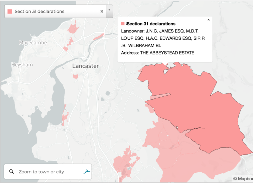
- The Duke of Westminster’s huge Abbeystead Estate in Lancashire: a 23,000-acre grouse moor that dominates the Forest of Bowland, but whose extent has not been mapped before;
- The Earl of Derby’s extensive estates outside Liverpool (the Earl is a close friend of former Chancellor George Osborne, who has lived in a house on another part of his estate in the Peak District);
- Large areas of college land around Cambridge (the sprawling estates of Oxford and Cambridge have been in the news recently);
- Farms owned by the Mormon Church in the Fenland – such as the 1,700-acre Woodwalton Estate in Cambridgeshire;
- The huge 21,000-acre Clinton Devon Estates in the West Country.
Uncovering hidden landowners
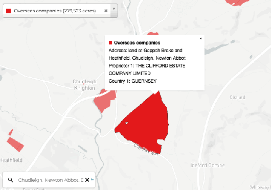
By overlaying these Section 31 maps with the other existing layers on our map, it may also prove possible to locate some previously secretive landowners. For example, check out instances where they overlap with areas of land on our Overseas & Offshore Companies map layer (shown in red).
The Ugbrooke Estate in Devon, for example, shows up on our Section 31 layer. A bit of Googling reveals the estate is owned by the ancient Clifford dynasty, currently headed up by the 14th Baron Clifford.
But it appears to overlap with land registered to the Clifford Estate Company, based in Guernsey. Has this old estate been deploying a rather more modern form of estate planning, by vesting its land in an offshore tax haven?
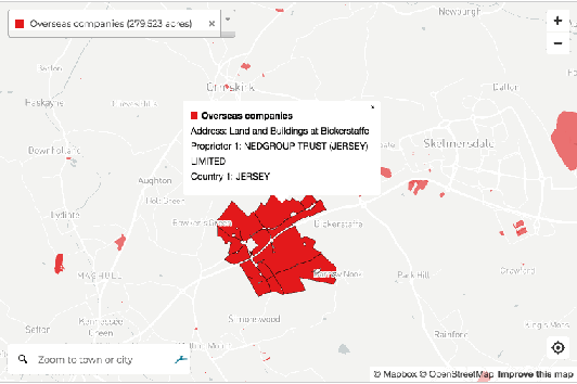
Similarly, land in Lancashire owned by Nedgroup Trust, headquartered in the offshore tax haven of Jersey, seems to overlap with the Earl of Derby’s estates in Lancashire (mentioned above).
We’re sure eagle-eyed readers will spot other examples – if you do, please post in the comments box below.
So, we’re another step towards mapping who owns England. But still a long way from our goal – the landowners we’ve now identified still only cover around 10% of the UK.
To map more, we need:
- More councils to digitise their Section 31 maps (or for someone out there to help us digitise them – we’ve been trying, it’s hard)
- We’ve said it before but we’ll say it again: we need to fully open up the Land Registry!

Great work people. Being familiar with GIS I can imagine transposing all of this data can take up a lot of your time up, so we’ll done. Open up the Land Registry indeed…if only they’d publish their rasta layers for free!
LikeLike
A simple way of revealing more details about ownership might be a tax on land values. Whoever pays the bill will reveal more about the hidden owners.
Locally (Bournemouth and surrounds) we have a large ‘land owner’ but older locals say that Oxford University actually owns it all.
It is well known that the value of land is related to the uses allowed on it – by planning decisions primarily – and to the availability of public services; roads, bridges, rail networks, schools, hospitals and less directly; the justice system, policing, military protection etc .
The focus has long been on the ‘cost’ of these services rather than the ‘value’ they create.
The difference between the two is the largely untaxed ‘economic rent’ which is what maintains these landowners in the position they enjoy.
True capitalism requires that the landowner pays the market price of the benefit each site receives, back to the community (via local government). Such a tax cannot be shifted on to tennants because rents are set in the broader markets. Lots of witheld land would be brought into use at true market rents – not the limited competition rents often seen now.
We remember the Magna Carta as a beneficial development but forget its darker side – shifting the tax burden from the land on to virtually landless peasants. Then the commons were enclosed removing that public safety net.
If this message is against the rules then my apologies and please remove it.
LikeLike
Chunks of Bournemouth still owned by family estates, Merrick, Portman etc. One ,the Porchester, I think also owns large parts of Anglesey, which is not within the scope of this book. Pity as he has allowed farmers to obliterate many inland footpaths and the local council is inactive . CD
LikeLike
It’s the Merrick’s that own over eighteen thousand acres on the Isle of Anglesey, maintenance of the footpaths is the responsibility of the local council, not the farmers on what’s left of the tenanted land !
LikeLike