
Image: Gerald Grosvenor, 6th Duke of Westminster (far left) and fellow Knights of the Garter. Source: Wikimedia Commons
It takes the death of an aristocrat to really bring out the forelock-tugging sycophant in the British media. “Because of Grosvenor’s wealth and prominence”, simpered Bryan Appleyard in the Sunday Times last weekend (£), bemoaning the sudden demise of Gerald Grosvenor, 6th Duke of Westminster, “his death feels like a requiem for the whole aristocracy and for the great political settlement… that stabilised Britain and laid the foundations of its brief greatness.”
Well, up to a point, Lord Copper. Asked for his advice on how young entrepreneurs should succeed, the late Gerald Grosvenor once replied: “Make sure they have an ancestor who was a very close friend of William the Conqueror.” It brings to mind the ominous words of Errol Childress, the villain in the first season of True Detective: “My family’s been here a long, long time.”
As an inspiration for aspiring, hard-working families in post-Brexit Britain, yearning to seize back control from the vested elites, the Grosvenor family is not… exactly the right role model. The new Earl of Westminster, 25-year-old Hugh Grosvenor, inherits from his father a fortune of some £9bn, having handily leapfrogged over his two elder sisters thanks to the arcane aristocratic tradition of male primogeniture. And the source of this stupendous wealth? Why, land and property, of course.
The Grosvenor Estate comprises some 140,000 acres of land across Scotland and England (or perhaps very slightly less: 133,000 acres according to this recent Daily Mail article). For the purposes of this post, I’ll be leaving aside their 94,817 acres of Scottish landholdings – Andy Wightman has covered these at Who Owns Scotland – and trying to map their English properties.
1) London: Mayfair and Belgravia (300 acres)
Source: Wikimedia Commons
The bulk of the Grosvenors’ vast fortune comes from the luck of being granted some marshy acres on the north bank of the Thames in the 17th century, which went on to become prime real estate in the world’s most overheated property market. Today, the family rakes in vast rents from owning 100 acres of Mayfair and 200 acres of Belgravia. This land is actually pretty well mapped: a recent article in The London Magazine has this map purporting to show the Grosvenor Estate holdings, tucked just behind and to the north of Buckingham Palace:
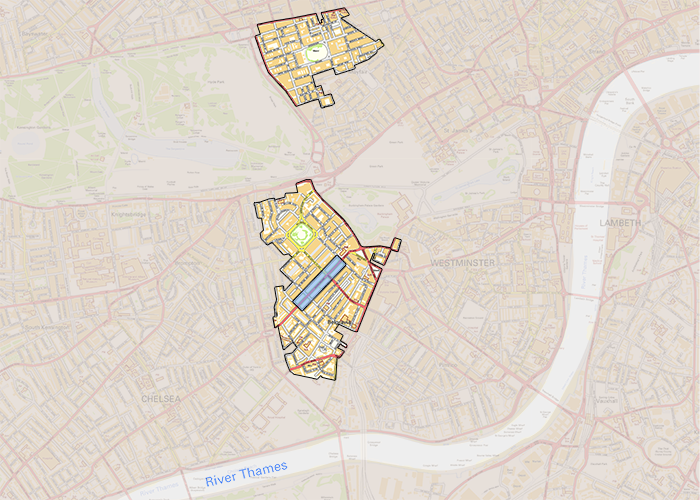
Still, it’s an interesting question exactly how many of these mansions, offices and retail outlets have now been sold off to other owners. Private Eye’s excellent map of properties owned and leased by offshore firms, for example, shows a fair few owning freeholds in Belgravia and Mayfair.
2) Cheshire: Grosvenor Farms / Eaton Estate (5,500 acres)
Far more tricky to get a handle on is the Grosvenors’ rural estates. This is where being a close friend of William the Conqueror really comes in handy – an aristocratic knack at keeping one’s lands away from the prying eyes of the envious peasants for the past thousand years. After all, there has been only one Domesday survey.*
To their credit, the website for Grosvenor Farms in Cheshire does at least tell us the size of their landholdings: “Grosvenor Farms is a mixed farm extending to 2,245 hectares (5,500 acres) on the Eaton Estate near Chester.” But mapping this is altogether harder.
One clue is by looking at farm subsidy payments. Grosvenor Farms Ltd claimed £637,709 in Common Agricultural Policy (CAP) farm payments in 2015, of which £39,182 was for agri-environment schemes. In 2014 Grosvenor Farms claimed even more – £913,516, with £106,075 of this for agri-environment schemes.
I mention the agri-environment schemes, because Natural England have maps of where these are in place. On their website, Grosvenor Farms allude to the locations of some of these schemes, stating: “The water meadows alongside the River Dee and its tributaries form some of the best low-lying wetlands in the country. They have been entered into the Environmental Stewardship Scheme…”. They also state that “Land not suitable for growing crops is sensitively managed as part of the Countryside Stewardship Scheme supporting many species of birds and maintaining habitats as well as sites of special scientific interest.”
Yet there is no sign whatsoever of these Environmental Stewardship schemes in the maps published by Natural England. In fact, the whole area around Alford Hall Farm, the HQ for Grosvenor Farms, appears blank:
Source: Natural England, Environmental Stewardship Scheme Agreements, available for download here. Contains public sector information licensed under the Open Government Licence v3.0.
Why? I’ve asked Natural England for clarification and will post any reply I get as an update.
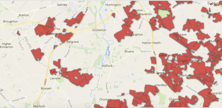
But there’s one other way to map the land owned by the Grosvenor Estate, and that’s to use an EU-mandated mapping dataset called INSPIRE Index Polygons. Mapping maestro Anna Powell-Smith has written a great introduction to using INSPIRE data here. As with much data on English land ownership, there are tough restrictions on republishing these in any useful format – you’ll need to follow Anna’s tips if you want to view the maps yourself in more detail. But below is a screengrab of the land parcels (turquoise) around Aldford Hall Farm, overlaid with the Environmental Stewardship schemes (red) mentioned earlier:

You can see that there’s a particularly large parcel of land right in the middle. I figured that would be the heart of the Grosvenor Estate in Cheshire, so selected the INSPIRE ID for it, and headed over to the Land Registry website – where, for £3 per land parcel, you can find out who owns England. Of course, at £3 a pop for every damn field, you and I would be bankrupted pretty quickly if we tried looking them up all one by one. But in this instance, my £3 paid off: that land parcel is indeed Grosvenor Estate land. You can read the land title for it – all 48 pages of it – here:
Grosvenor Estate – Grosvenor Farms/ Eaton Hall land title
That’s far from the whole Grosvenor Estate in Cheshire – they doubtless own many of the surrounding fields too. But it shows you the heart of it, and illustrates how difficult it is to track this hidden information down.
3) Lancashire: Abbeystead Estate (600+ acres)
The third and last English landholding of the Grosvenors is the sporting estate at Abbeystead in the Forest of Bowland, Lancashire (here). The estate’s website states it contains at least 600 acres of forest, and we are led to assume this is not the whole of the property.
On Environmental Stewardship maps, two relatively small land parcels are marked as being administered by the Trustees of the 4th Duke of Westminster’s 1964 Settlement, and brought in a mere £7,227 in 2014.
It’s pretty clear that Abbeystead also takes in much moorland, including grouse moors – that special form of aristocratic land management that helps to keep our uplands bare of trees, our hen harriers persecuted, and our front rooms flooded when the hard rains fall.
Missing acres
To conclude. With 94,817 acres in Scotland, 300 in London, 5,500 in Cheshire and at least 600 in Lancashire, that’s some 101,217 acres of the Grosvenor Estate that we’ve located and mapped (more or less). But that still leaves somewhere between 32,000 and 48,000 acres unaccounted for. Where are they? And where, precisely, are the farming schemes in Cheshire for which the Grosvenors are receiving hundreds of thousands of pounds of public money? More fundamentally: why is it still ok for such vast swathes of England, our England, to be owned and inherited by such a tiny, privileged elite?
Without a second Domesday survey to open up who owns England, the close friends of William the Conqueror will continue to run the show.
*More on the hushed-up 19th-century ‘Second Domesday’ survey another time.

Reblogged this on sideshowtog.
LikeLike
We’ll keep the red flag flying here!
LikeLiked by 1 person
Nice one, Guy-keep up the good work.
LikeLike
Excellent article and well researched thanks for posting. Makes one blood boil reading about those subsidies
LikeLike
Hi, when filling in the gaps of on the late Duke’s landholdings worth having a look at the large Liverpool One development area in Liverpool city centre. I’m not sure if Grosvenor Estates is the exclusive landowner, but they were certainly the developer. Liverpool readers may know more. Despite plenty of controversy, especially over privatisation of the public highway, they actually did a good job and – IMHO – has been a net positive for Liverpool in terms of bringing in visitors and shoppers and transforming a rundown area of town.
LikeLike
Thanks – good tip off! I have a sneaking suspicion the Liverpool One land may be owned by Peel Group, another major landowner who I hope to write more about in future. Any further leads on either, much appreciated… 🙂
LikeLike
In a similar vein, it might be worth also checking the Grand Arcade shopping development in Cambridge for links with Grosvenor Estates
LikeLike
you can find a map of the eaton estate on the cheshire west council website.Go to the pages on public rights of way and follow the links to section 31(6) deposits-an invaluable and too little known resource.
LikeLike
Why wont the Labour Party acknowledge that a Land Value Tax as first proposed by Lloyd George in his peoples budget of 1909 is well overdue?
I cannot get any answer to this, despite asking the Labour party this question repeatedly for ten years.
LikeLike
Land value tax is dependent on the value of land, yes? But the value of land is dependent on the demand of it, if estates sell of land to pay the tax, there will be a lot of land on the market and this will depress the value of each estate. Furthermore, whatever revenue the tax has gained will be spent on personnel and equipment to inspect and value the land. Finally, who do you think the buyers of the land will be. I suspect it is more likely that the land will go to some offshore company or Russian mobster rather than the “common people” If that’s the case, I would much prefer the land to be locally owned
LikeLike
I wish someone made a custom Google Map that would clearly delineate the boundaries of the estates of central London. It would be amazing to have the Crown, Grosvenor, Cadogan, Portman, Howard de Walden, and City of London estates mapped in detail. There is a small FT map circulating around, but it would be lovely to see all that at street level.
LikeLike
Thanks James! Funnily enough, that’s exactly what I’m doing for my next blog on here – who owns central London. Watch this space… 🙂
LikeLike
As a geeky aside, apparently the Grosvenor Estate has mineral rights in North East Wales, though whether they are currently generating revenue, I am not sure. There is a fleeting reference to this about half way down this page: https://sites.google.com/site/flintshireleadmining/Home.
In general, mineral extraction rights can be owned independently of the ownership of land in the normal sense, it seems.
[Property taxes of various sorts are all very well but, of course, what we really need is the positive transcending of bourgeois property rights as well as residual feudal ones, which can only be achieved by the working class taking power globally and making direct collective democratic decisions about the allocation of resources, rather than this happening through the chaos created by the dictatorship of capital. Marxist Rant ends.]
LikeLike