
Updated 9th June 2017 with more landowner registers.
In the eighteenth century, highwaymen were the bane of aristocratic travellers, ambushing their coaches on dark roads as they journeyed from townhouse to country estate. Some, like Dick Turpin, came from humble backgrounds, and became seen as robber-heroes – latter-day Robin Hoods, stealing from the rich to give to the poor with their cry of ‘stand and deliver!’.
It would be hard to describe the obscure Section 31(6) of the otherwise exceptionally boring Highways Act 1980 as being a secret agent of social redistribution. But it does at least help uncover some of the vast private estates that still dominate land ownership in England today.
In a nutshell, the Highways Act 1980, s31(6), obliges Local Authorities to keep a public register of all landowners through whose land run public highways and rights of way (such as footpaths, bridleways and roads). This is both to help Local Authorities identify such rights of way, and protect landowners from claims that additional rights of way exist. To register, a landowner has to deposit a statement and a map with their Local Authority – showing very clearly the boundary of their land.
This makes the Act a very helpful resource for obtaining information on private landowners and the extent of their estates, who are otherwise not subject to FOI requests or public sector transparency requirements, and have little interest in volunteering information about their land holdings.
I’m very grateful to a reader of this blog, local historian Nick, who pointed this out to me late last year. Since then, I’ve been gradually piecing together a database of all registers of landowner deposits kept by Local Authorities under the provisions of the Highways Act. For England, that means collating the registers kept by all 152 County and Unitary Authorities, a big task. I’ve not quite finished doing so yet, but you can see where I’ve got to so far in this Google Fusion Table (screengrab of map below). (Updated fusion table & map 9th June 2017 with more registers)

The grey Local Authority areas are ones I’ve not done yet, whilst the red ones are where I’ve got FOI requests pending. The light green Local Authorities are those I’ve found landowner deposit registers for; and the dark green ones are the most interesting, as I explain below.
For most Local Authorities that I’ve looked at, their landowner deposit registers are pretty basic – a webpage listing landowners who’ve made a deposit, with links to PDFs of their full statements and maps. Some councils, in vague efforts to be helpful, have built search engines into their registers, or grouped their lists by parishes. Click through to each map, and you’ll usually get to see an Ordnance Survey or similar high-quality map, with the boundaries of the estate in question outlined in colour. So, this is useful if you’re looking to build up a map of local land ownership – but it’d be very laborious to stitch together all the PDF maps to see a broader picture.
However, some Local Authorities – those shown in dark green – have gone one step further. They’ve published interactive online maps showing the boundaries of all the landowners they’ve received maps and statements from. This is incredibly helpful. Let’s take a look at some of these maps.
1) Devon
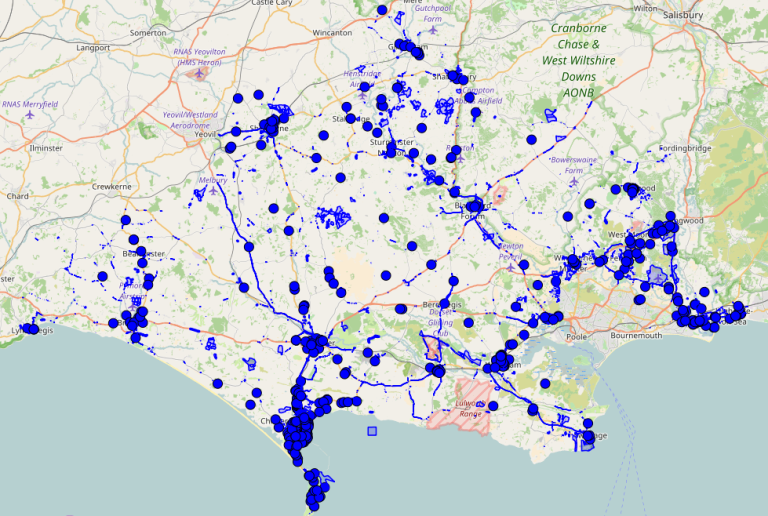
Let’s begin with Devon and Somerset (classic highwayman territory, as immortalised in Lorna Doone). Devon County Council has published a very good map of landowner deposits, revealing the extent of a lot of large private estates. The map displays the land parcels in pink, and when you click on one, it highlights all land owned by the same owner in bright turquoise. An example screengrab is below – showing the huge Clinton Devon Estates, which, according to the Estate’s own website, covers around 25,000 acres. They received £267k in public farm subsidies in 2015.

2) Somerset
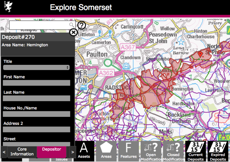
Having surveyed the wealth of some of Devon’s great estates, let’s hit the highway for Somerset. Here, the council also has a nice map highlighting landholdings, but you can only zoom out so far before this layer disappears – so it’s hard to see the full picture. When you click on a polygon, it’ll bring up details of the landowner, but won’t highlight the boundary of the land they own – you have to keep clicking around to check if there’s a break in the boundary. And there are glitches in the records – for example, see the screengrab below: this shows a large private estate near Radstock, but when you click on it, no landowner information appears. It takes some further digging – a close look for stately homes on the underlying map, and some googling – to reveal that this is probably the family estate of the 5th Baron Hylton, whose son lives at Ammerdown House.
3) Dorset
Dorset County Council doesn’t actually display the deposited holdings of private landowners on their map, but I think it merits a special mention because it’s a really good use of mapping software, with multiple useful layers – and it does show all land owned by the County Council (see screengrab below). Some badgering of the Council to upload all their landowner deposits would be worthwhile – they clearly have the GIS know-how to do this.
4) Cambridge
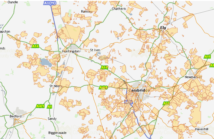
Now, galloping onwards, to Cambridgeshire, home to the land-rich University colleges and some big grain barons. Cambridgeshire Council’s map is very comprehensive, displaying the landowners of a large percentage of the county. But though you can click on a polygon and see the landowner, the map doesn’t highlight all that owner’s land at once – you have to click on each polygon to check. One of the largest single land parcels belongs to the Abbots Ripton Estate (just north of Huntingdon) – who, besides being big farmers of barley and sugar beet, host the annual Secret Garden Party music festival.
5) West Berkshire
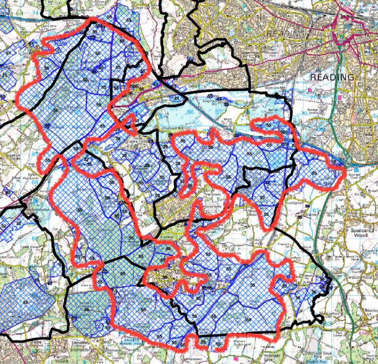
But I’m saving the best until last – the rich pickings of the Royal County of Berkshire, or to be more precise, West Berkshire (a place that was my childhood home). West Berkshire Council have put together what appears at first to be an impressive online map, showing extensive landholdings, but which – when you try to ask it for information on each land parcel – quickly falls apart. However, all is not lost. Perhaps sensing their online map is not quite up to scratch, the Council have also released a detailed PDF map showing all estates for which they have received landowner deposits, and – crucially – an index, allowing us to match up numbered land parcels with their owners. And as you can see, West Berks is dominated by huge landed estates:

Having grown up in Newbury in West Berks as a kid, I knew it was a pretty wealthy area with some big landowners. What I didn’t know about was the size of the estate owned by the current MP for Newbury, Richard Benyon, who is the richest MP in the House of Commons with an estimated wealth of £110 million. Mr Benyon came in for some heavy criticism when he was Environment Minister for the millions of pounds he earned in public farm subsidies for his estate, and for his support for grouse moors. Now you can see the full extent of Mr Benyon’s Englefield Estate, thanks to West Berkshire council’s map:
6) Rutland, North Somerset, Doncaster, Wakefield, Lancashire
Since first posting this blog in January, I’ve found more councils who have digitised their s31.6 landowner deposits. Lancashire has a great map here (on the lefthand sidebar, go to ‘Countryside, Environment & Waste’ > Landowner deposits). Rutland has a good online map here; North Somerset’s online map is here, though they’ve not had many landowner deposits; Doncaster here, and Wakefield here.
Your money or your… map?
Sadly, this obscure piece of legislation isn’t a silver bullet answer to this blog’s driving question of ‘Who owns England?’. As this survey has shown, the information obtainable from Highways Act landowner deposits remains piecemeal. Even with the councils who’ve taken greater steps to make maps available, none of them let you download the GIS data. (Since first writing this post, I’ve sent FOI requests to a number of the councils and some have released their GIS data to me – e.g. see my blog about West Berkshire land ownership here. I’ll be analysing and publishing more soon).
Maps deposited under the Highways Act are never going to give us a comprehensive picture of land ownership. The best way to do that is to open up the Land Registry. But in the meantime, it’s another step towards holding large private landowners to account. Stand and deliver!

Fine work here Guy! keep on at it. The Benyon Estate of course was involved in recent Turpitude in East London, Hackney I think, where if I remember rightly they ended up backing down from evicting all the residents of an “estate” they own; it may be they sold the property on to a Housing association – a nice result from embarrassing a Tory MP. I hope that is true. Does that ring a bell? My likely source is the Islington Tribune, but it could be Private Eye. I’d guess it was summer 2015.
LikeLike
Great work! Very interesting
LikeLike
Is there a way I can help compile some of the data? How would I query the local authority?
LikeLike
Hi David, thanks for the offer! The best way, I’ve found, is simply to google ‘Highways Act 1980 section 31(6) landowner deposits’, with the name of the council – or a variation on those words (e.g. simply ‘landowner deposits register’). Sometimes, you’ll need to go onto the council’s website and search that, as they don’t always turn up on Google straightaway. Any results you get, please post them as comments and I’ll upload them to the database! Cheers 🙂
LikeLike
Not getting much from that. Six PDFs, to be exact. The two that contain recipient addresses are sent to a) the planning directorate and b) the Public Rights of Way office.
So, do I try to locate a mapping officer, or just do a FOI and let them figure it out?
As for the PDFs, or converting to geodata, what would suit?
LikeLike
Good work, i saw some results which may be of use to you https://www.whatdotheyknow.com/user/stephen_adamson_2?page=3
LikeLike
Hey David – do you mean you’ve looked for a register for a particular council and it’s not turned up anything? If so, probably best to FOI them, yes. Lots of council websites are a mess! Re the data itself – I haven’t even attempted to start going through all the PDF maps on council registers, it’s just such a huge task, so haven’t really considered a way to pool all this yet. If you’re keen, you could start making a database for the council you’re looking into, stitching together the existing PDF maps, or maybe (if you’re really keen) looking out the INSPIRE polygons that correspond to the estate boundaries shown in the PDFs.
LikeLike
OK. FOI looks like the next step, so maybe you’ll next hear from me in a month! I was chatting with a ward cllr today and asked if he knew where landowner deposits were made – and he said, nowt to do with us, it all goes to Coventry. I’m pretty sure I needed to post the question differently for him to get what I was on about.
Inspire. Never heard of it. So I suppose I’ll make a GPX file, upload it to google, and point you to it.
LikeLiked by 1 person
glad you have found sec 31-6 deposits.i’ve been following them for years.some councils are incredibly dilatory about them-my own Warwickshire for instance.worcestershire used to have a map but this disappeared some time ago, now theres just a list but no links to info ditto Essex.powys used to post that the information was ‘coming soon’-it never did.northants pleads lack of staff but does publish new deposits.notts was at some point making a start but the effort seems to have fizzled out.we are fortunate that some councils have made the effort they have-plaudits to Norfolk,suffolk and Cambridgeshire especially.let me add finally that local authority planning websites can be trawled for information especially in relation to farm related planning applications.good luck with the project, happy to help all I can.
LikeLike
Thanks Steven! That’s very helpful. I’m keen to complete the database, if you have any links you can share I’ll gladly put them into the Google Fusion Table linked to above and update the map! Re Warwickshire – I’m sure you’re right that they’ve not been very transparent – though they now seem to have s31(6) deposits here? – https://www.warwickshire.gov.uk/propertypublicrightsofway — though no map, of course!
LikeLike
Oh, look!
https://www.birmingham.gov.uk/downloads/download/696/download_section_316_deposits_section_15a_of_the_commons_act_2006_and_land_owner_deposits
There’s a web page after all… with fewer deposits than I’d hoped, and none of them inner city areas, but some info nonetheless.
LikeLike
Thanks David! Nice one – I’ll update the map with this link.
LikeLike
Thanks a lot for sharing such an informative post.
LikeLike
Me again, after a long hiatus and a move to a different county.
Recntly started looking at ownership matters in a couple of villages, and have now found the County web page with the current list of deposits.
https://www.durham.gov.uk/article/6427/Public-Rights-of-Way-and-Village-Green-Landowner-Deposits
LikeLike