
Photo © Robin Drayton (cc-by-sa/2.0)
This post is by Anna Powell-Smith and Guy Shrubsole
One issue that keeps cropping up in debates about the housing crisis is whether developers and landowners are ‘land banking’ – that is to say, sitting on undeveloped plots of land waiting for them to increase in value before building on them.
In today’s Budget, Chancellor Philip Hammond is expected to announce – according to the Sunday Times (£) – a review of land banking by housing developers.
So we set out to use the newly-released Corporate & Commercial dataset to investigate land banking. It’s a topic explored on Who Owns England before – but previously we’ve only known how many acres the largest housing developers owned through their top-level PLCs. Now we have details of individual titles.
We began by looking at the 11 largest publicly listed housebuilders in the UK, tracking their subsidiary companies via the Persons of Significant Control data from Companies House. We found more than 42,000 titles owned through more than 1,400 companies. (By our calculations, Taylor Wimpey alone owns more than 12,000 titles via more than 400 companies.)
We mapped them all by postcode or address – the data doesn’t include any geospatial information, so all the locations are approximate and point level only:

Then we started looking at the land owned around cities, since lots of titles are owned in dormitory towns around the commuter belt. Titles include housing where the developers have retained the freehold, plus bits of leftover land from past building projects and vacant plots. Here’s a rough map of the Persimmon titles around London:
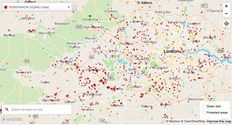
We looked particularly closely at the areas around the capital: to the west, on the outskirts of the Green Belt and sandwiched between the Chilterns and Surrey Hills AONBs, developers own scores of sites around Aldershot, Farnborough, Bracknell, Wokingham and Reading.
There’s clear clustering on the edges of the Green Belt and just outside AONBs, where the planning restraints are greater:

Finally, we started to explore individual titles – first checking how long they’d been owned, then buying the titles to confirm the exact boundaries, and finally using Google Street View to confirm whether they’ve been built on.

This was a slow and frustrating process – many times we bought titles only to find that the land had already been built on, or that it was in quite a different location from the postcode centroid on the map. Sadly, our conclusion is this: the available Land Registry data as it stands makes it impossible to meaningfully explore land banking.
Problems with the data
We know a bit more about how many titles each housebuilder owns (see table below), and have a very rough map of where some of them are, but that’s it.
This is because the Land Registry data includes no useful geographic information:
- No boundaries. We don’t have any boundaries, or even the area of each title, so we can only map titles as points. To find out exactly what land is covered, we still have to buy individual titles. The lack of geographic boundaries also means we don’t know whether a plot of land is large or small – so we still have no real idea of where the housebuilders control significant amounts of land.
- Locations are only ever approximate. In the best cases, the addresses have postcodes, so we can map them to postcode centroid – but this is only true for about 7,000 of the 42,000 titles.
- Locations are often (inevitably) wildly inaccurate. Usually, we only have the address, so we have to use an OpenStreetMap-based geocoder (the excellent OpenCage). But the addresses are messy – they weren’t designed to be used for mapping – and the poor geocoder struggles with them. It returns an estimate of its confidence in each address, and we think probably only half of the titles are even reasonably accurate.
All this makes it more or less impossible to do serious investigation, at least without making this our full-time job. We think we can improve the geocoding somewhat, and will work on this – but even in the best case, we’ll only ever have point-level, approximate data.
We have published the map, with giant caveats plastered all over it: http://housebuilders.whoownsengland.org – sorry, you’ll need to enter your name and email to see it. You can also get the raw data there.
(Of course, even with perfect data, we’d still have the problem that housebuilders can control land through option agreements, which are private legal documents. The government has pledged to create a register of option agreements, but this is a long way off, and may not be public when it does appear.)
What we do know
We have been able to work out the companies that each PLC controls, via the Persons of Significant Control dataset, and match them (messily and incompletely, since the C&C data contains typos and so on) against the Corporate & Commercial data, to find the number of titles they own. Here’s the full table of what we found.
| PLC name | Number of subsidiaries that own land | Total number of titles found |
| Barratt Developments | 242 | 6,781 |
| Bellway | 54 | 2,452 |
| Berkeley Group | 116 | 1,466 |
| Bovis Homes | 29 | 580 |
| Countryside | 49 | 697 |
| Crest Nicholson Holdings | 83 | 1,514 |
| Galliford Try | 101 | 1,443 |
| McCarthy & Stone | 14 | 1,778 |
| Persimmon | 389 | 10,840 |
| Redrow | 54 | 2,041 |
| Taylor Wimpey | 322 | 12,817 |
Of course, the lack of geospatial information is down to Ordnance Survey – they claim that they own all geospatial information derived from their maps (Anna has written about this before). That’s why – even in 2017, even with a housing market that everyone agrees is broken – we still don’t really know what our biggest housebuilders own, or where, or what they’re doing with it.
It’s hard to overstate how frustrating this is – we’ve shone a tiny light on the murky world of what the housebuilders own, but for now, darkness still covers the land. We hope this will change soon – perhaps very soon. Chancellor, the ball is in your court.

Excellent work. Its a travesty that the land data is locked up (privatised) in so many jurisdictions just as geo-spatial analysis such as this is about to flourish. In the major development estates, how long do they drip feed the sites for? Here in Australia they cry poor re land supply whilst simultaneously boasting to their investors that they will drip feed the estate for 20+ years. Talk about realestate4ransom.com
LikeLike
Hi guys,
I had a method question. You said you used OpenCage to geocode your addresses. I’m attempting to do a similar bulk geocoding of addresses for a project of my own. However, when I looked up OpenCage they said they did not support bulk geocoding. However, I don’t expect that you entered all 42,000 titles you found one at a time. As such, I wanted to ask you how you geocoded your data, in the hope that I might be able to do the same. Currently I’m using this Batch Geocoding program and averaging about 1,000 geocodes p/day in chunks of 300 – https://www.doogal.co.uk/BatchGeocoding.php. As such I’d really appreciate knowing how to employ a faster option, on my quite limited budget.
Thank you for your time.
Best wishes.
Adam Brodie
LikeLike
Hi Adam! The addresses with postcodes I geocoded for free using Code-Point Open with a database lookup. The addresses without postcodes I geocoded using a script that queries the OpenCage API. I have an account with the Small plan, which supports up to 20,000 requests per day. It’s pretty good value – see https://geocoder.opencagedata.com/pricing
LikeLike
Hi Anna,
Many thanks for getting back to me.
I’m afraid I’m quite a novice when it comes to mapping. So when you mention using a script querying the opencage geocoder API I am unfortunately non-comprehending. Would it be possible for you to point me to some resources that might teach me how to do what you did here? I recognise this is work on your part, so no worries if it’s too big a request. It’s just that I don’t even know where to start.
Best wishes,
Adam
LikeLike
Should not this dormant land presumably zoned as development land be subject to an acreage disclosure and be subject to a council tax levy,as if you leave a house empty in most Council areas full council tax becomes payable,a time regulated scheme setting a limit on the requirement for outline planning permission and also for commencement of works should benefit legitimate council tax payers to a considerable amount.
LikeLike