
Get close to land owned by the Ministry of Defence (MOD), and you’ll soon know it from the profusion of threatening signs: MOD PROPERTY – KEEP OUT. Some MOD sites have bylaws prohibiting photography, and during the height of the Cold War, top secret military sites were infamously scrubbed from Ordnance Survey maps, leaving them peppered with suspicious blank patches. It’s a helluva big area to keep covered up: the MOD own some 750,000 acres, making them the second-biggest landowner in the UK after the Forestry Commission.
Given this history of paranoia about the location of their properties, then, I was surprised when the Ministry of Defence released to me a map of their entire UK estate.
Granted, it had taken a while. A couple of years ago I’d made a Freedom of Information (FOI) request to the MOD for maps of the flood risk faced by their properties, and been rejected on grounds of ‘national security’. This was a tad inconsistent, because they’d already sent me a report on flood risk to MOD sites, which included two maps of their sites – grainy in quality, but quite possible to see where their major landholdings were.
Later, when the Coalition Government introduced its Government Property Finder online service – an initiative aimed at flogging off underused bits of public property – I was bemused to see that it contained a complete list of military properties, and downloaded the lot quickly. Good job I did, because the list of military sites soon disappeared, with only the MOD’s civil properties currently listed. But you can check out the full list of military sites here:
Properties owned by MOD military Aug 2014
Still, whilst this gave me some point location data for each of their sites, it didn’t give me the actual outlines of their land holdings.
So the other month I tried again, lodging an FOI for a map of all the MOD’s land. This time, it worked. And here they are:
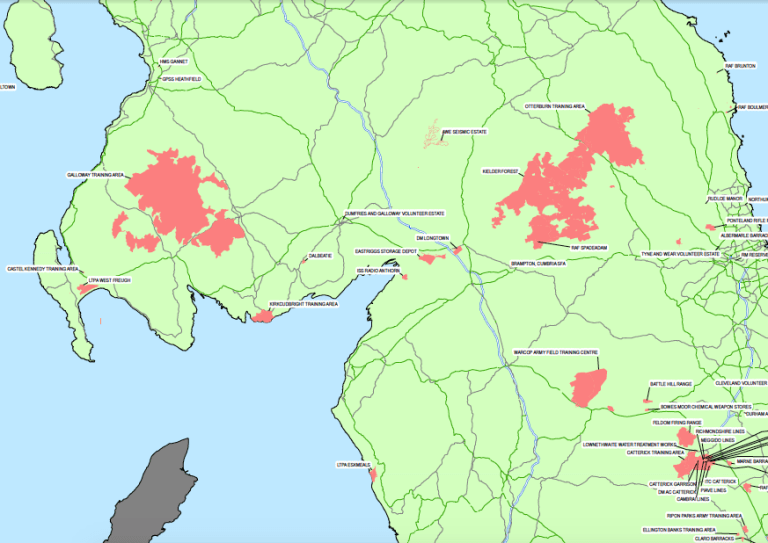
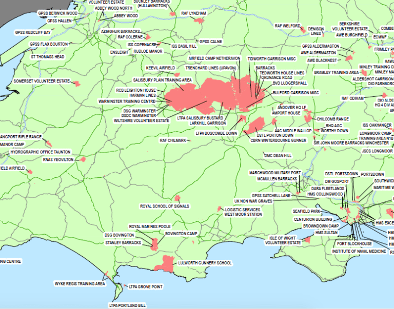
What I’d actually requested, however, was a GIS map (i.e. a digital map that could be analysed and overlaid with other GIS data, not just a static PDF file). So that’s what I’ve gone back to the Ministry to ask for. I’ll let you know if I get it – or if I’m met with the digital equivalent of MOD PROPERTY: KEEP OUT.

It’s interesting to hone down on who owns MOD as well. Here in Oxfordshire, I talked to service-people at RAF Benson about the energy efficiency of their homes. It turned out that the homes were owned by a private, foreign company.
LikeLike
Following on from the revelation about the houses at RAF Benson, I was also going to ask: on what basis is all this land held by the MOD? Long leases? Some special requisition arrangement that allows the government to take over territory? With what arrangements for compensation – one-off or ongoing? What would the Land Registry show us about the actual titles to these chunks of territory?
LikeLike
Guy – did you get anywhere with your request for a GIS layer of MOD land? Keep up the good work
LikeLike
Hi Tom, I did thankyou – a friend was able to extract the GIS data from the PDF file that the MOD supplied, and we’ve added that to our big map of all known landowners, here: http://map.whoownsengland.org/
The extract wasn’t perfect, it’s quite grainy when you zoom in close, but it gives you a pretty good idea of the boundaries and overall area they own.
LikeLike
Guy how would I find out who manages mod land for them any ideas? I’m trying to chase up a job surveying their trees in Nottinghamshire also once I am housed in in a caravan for next two months I can help you digitise GIS data
LikeLike
These are the Aldershot MoD holdings from 2019, if of use? https://assets.publishing.service.gov.uk/government/uploads/system/uploads/attachment_data/file/813264/20190318-FOI02298_House.pdf
LikeLike
Can you provide more detailed map of the Ministry of Defence holding at Warcop Training Camp, Cumbria, please? We are currently giving evidence to a Planning Enquiry about the proposal to build a new road through the site of an ancient Charter fair, and the Land Registry title has mysteriously disappeared. (It was there two years ago, but has ‘vanished’. ) If your map shows the land in question as MoD land at the time of your FoI request, it will assist our argument. Thanks. Bill
LikeLike
Hi there! Thanks for your work in this, plugging the gaps of Englands ideosyncratic data world. Is there any way you could make the MoD map layer available as a shapefile? Its remarkable but as far as I can see theres still nothing else like it out there
LikeLike
The Arborfield Garrison (MOD) was sold to Crest Nicholson some years ago. Crest sold off land parcels to Redrow, Taylor Wimpey, David Wilson Homes, Legal & General (Cala Homes), and Bewley Homes.
LikeLike