
Grouse moors cover an area of England the size of Greater London, and rake in millions in public farm subsidies. That’s the conclusion of an investigation I’ve carried out for Friends of the Earth – with the kind assistance of an academic who wishes to remain anonymous – and which appears in today’s Guardian.
Grouse shooting is a blood sport enjoyed by so few people that even the Spectator calls it “screamingly elitist”– the pastime of landed aristocrats, City boys and billionaire businessmen. It is also environmentally damaging: the management of grouse moorland involves burning huge tracts of heather every year, to boost grouse populations. This degrades the underlying peat, releases soil carbon and, studies show, may well lead to significantly worse flooding downstream.
Yet incredibly the owners of grouse moors continue to receive millions of pounds annually in taxpayers’ money via our broken farm subsidy system, the EU Common Agricultural Policy (CAP). Post-Brexit, this system is in urgent need of reform, so that public money only goes to fund public goods, like reducing flooding and restoring ecosystems.
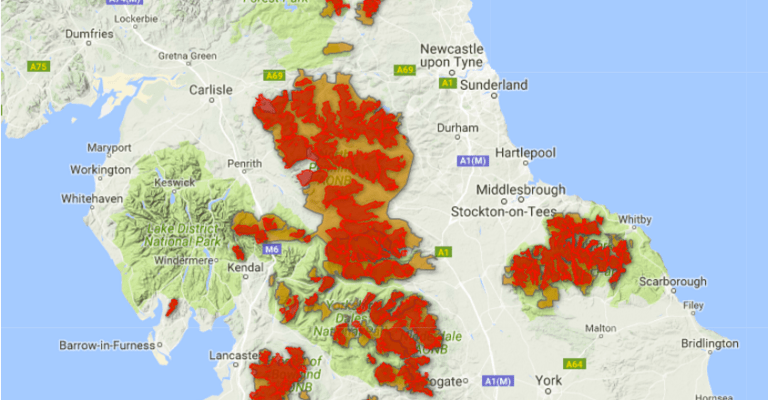
Our investigation lays bare just how much of England has been taken over by grouse moors: an area of at least 550,000 acres, as big as London inside the M25. We have digitally mapped, for the first time, the extent of grouse moors in England. And we have identified the owners of 30 grouse moor estates covering 300,000 acres, who received over £4million in public subsidy in 2014 – and 4 of which are owned offshore.
Mapping the grouse moors
Despite their size, there is very little readily-available information about the location and extent of grouse moors in the UK – almost as if their owners would rather keep their existence secret. After much searching, I found, buried on the website of the Moorland Association (an organisation that represents the grouse shooting lobby), a PDF map purporting to show Keepered Grouse Moors. I requested by email and then via Twitter that they release this map in a more useful digital format, but they declined. However, it is possible to extract GIS data from PDFs, and after a kind offer of assistance from an anonymous academic, this is what we did.
The Moorland Association’s map data suggests that English grouse moors cover 1.3million acres, or almost 4% of England (which is 32million acres in total). However, their map appears to be quite crude, and we opted to refine it by sense-checking it against a number of Government land-use datasets and satellite imagery. You can read our full research methodology here. Aerial photographs, like the one below, show up the distinctive patterning of grouse moors, where huge strips of heather have been burned or cut extensively. Following our checks, our best estimate is that grouse moors in England cover some 547,937 acres. Our maps are online here.

Investigating grouse moor estates
But who owns these vast expanses of grouse moor?
Having the above maps allowed me to compare areas of grouse moor with Land Registry INSPIRE polygons showing land parcels, and begin to pin down some of the major estates.
Through a laborious process involving Land Registry searches, the purchase of title deeds, and examining maps deposited under section 31(6) of the Highways Act 1980, I’ve been able to identify 30 grouse moor-owning estates, together covering over 300,000 acres. The full research methodology is set out here.
All 30 estates are detailed in this Googledocs spreadsheet. They include the Grosvenor’s Abbeystead Estate in the Forest of Bowland; Bolton Abbey Estate, owned by the Duke of Devonshire; and the 26,000-acre Gunnerside Estate, belonging to Robert Warren Miller, an American-born British billionaire who made his fortune from duty-free shops – and whose estate is registered in the British Virgin Islands. Indeed, 4 out of the 30 grouse moor estates I have looked into are owned offshore. A large chunk of the Yorkshire Dales is essentially owned in Lichtenstein, Guernsey and the Caribbean.
Despite this, the great majority of the grouse moor estates I have investigated are recipients of taxpayer subsidy under the CAP. These 30 estates received a total of £4million in 2014.
Publication of INSPIRE polygons mapping land ownership is governed by restrictive licensing. As this, however, is a current news event, with a clear public interest in understanding who the recipients of public funds are and the extent of their land holdings, I am publishing these maps under fair dealing. I will take them down if asked to do so by Ordnance Survey.
Firstly, 10 grouse moor estates in the North Pennines:
Secondly, 10 grouse moor estates in the Yorkshire Dales:
And lastly, 10 grouse moor estates in other parts of England:
On Monday 31st October 2016, MPs will for the first time debate banning driven grouse shooting – thanks to a 120,000-signatory petition by veteran wildlife campaigner Mark Avery. There are huge questions to be asked about the wisdom of handing out millions of pounds of taxpayers’ money to wealthy landowners to prop up an elitist sport that does considerable damage to ecosystems, increases flood risk, and gobbles up hundreds of thousands of acres of England. Theresa May has promised to build “an economy that works for everybody”. Grouse moors surely epitomise the opposite of that.

this really is groundbreaking work Guy – congratulations.
I have a few follow up questions, which hopefully simple interrogation of your GIS data set will enable you to easily answer.
Of the £4M paid out in CAP subsidies in 2014, what is the proportion paid as single payment, and how much is paid via agri-environment schemes? Bearing in mind that single payment is not really rationed, but agri-environment payments really are, this would be another interesting angle to explore.
How many of the 550,000 acres – a staggering figure in itself, are designated as Sites of Special Scientific Interest, Special Protection Areas under the Birds Directive, and/or Special Area of Conservation under the Habitats Directive?
You mention 4 of the 30 identified owners are offshore in tax havens. What proportion of the land, and what proportion of the £4M is being paid out to these offshore entities?
LikeLike
the subsidies mostly go t0 the tenant farmers who keep live stock on the land, such as a majority of sheep on croglin (which do more damage to the heather than burning as they eat the shoots, so it cannot re grow) and of the conservation of moorland, subsidies will go as repayment of expenditure towards the maintenance of the moorland itself not the grouse, as it is a man made environment that is maintained by man, but it will not fully cover the expenditure, without the shooting side moorland maintenance is a drain on money, so most moors that stop go unkept and grouse start to die off, along with birds of prey on the land from decreased food stock.
there are many RSPB moors around the country, which do not participate in the act of shooting or keeping the land, occasionally mowing the heather to stop over growth, but not enough to have enough grouse to feed the birds of prey like on grouse moors.
my final point is that working in a land agency I have never before seen the subsidies go to the moor owner them self, rather the keepers and tenants of the moor who keep it, people who wright these articles just broaden the payment to ‘the moor’, then directing it to the owner not the recipients. don’t believe everything you read online is true, try consult someone who lives near the moor or actually works on one in a peaceful manner
side note, moorland shoots also support local economies, with mechanics, caterers, beaters etc, these are people who would suffer at the lose of the ending of the shooting practice, with it being a ‘richmans hobby’ they have little intent of making money off of it, they are rich after all, but they do pump a lot of money into it to keep it going, meaning not so well off people make profits off of it not the other way around
LikeLiked by 1 person
“But not enough to have enough grouse to feed the birds of prey like on grouse moors”
This is, of course, completely untrue. RSPB reserves support 10% of the Hen harrier population, whilst only possessing 1% of the moorland. The whole driven grouse shooting industry is propped up by organised criminality in order to exist, which has been proven time and time again. Eco tourism dwarfs shooting in terms of money spent, so if that’s the last argument for driven grouse shooting, it really is the end of the line.
LikeLike
Although I’d agree with questioning the ethics of tax payers supporting Grouse shooting, surely there are other reasons to support the bio-diversity created by these types of environments which seems to have been overlooked.
LikeLike
Reblogged this on discordion {Artist Ian Pritchard} and commented:
Research by Guy Shrubsole, FoE.
LikeLike
With the drought, and this a recurring feature, it maybe possible that these fires will burn for years. A major concern is the old industrial pollutants from dumping, etc. now going up with the smoke and coming back down over densely settled areas and agricultural land.
LikeLike