
This post is by Guy Shrubsole.
For the first time, Who Owns England can reveal a map of land owned by two of England’s biggest water companies, United Utilities and Yorkshire Water – whose landholdings together span over 200,000 acres.
As a result, I can also reveal the Sites of Special Scientific Interest (SSSIs) owned by these water companies, many of which are in a poor state. Just 16% of SSSIs owned by England’s water companies overall are in a favourable condition, according to official data that I shared with the Guardian this past week.
These shocking stats underline the need to make major landowners, including water companies, accountable for how they manage their land. Whilst Labour’s Environment Secretary Steve Reed has just announced new measures to better regulate water companies that pump sewage into our rivers, a lot of river pollution starts further upstream – in the vast watersheds owned by the companies themselves. Overgrazing by sheep, nitrates run-off from livestock manure, and peat erosion caused by intensive grouse moor management all contribute to downstream river pollution. These peat bogs are also vital carbon stores and natural habitats in their own right, yet as the SSSI data suggests, in a bad state.
Labour has a golden opportunity to set up a new Public Nature Estate, ensuring public landowners and statutory undertakers like the water companies are duty-bound to manage their land for nature and carbon.
The maps
Here’s a static map showing the land owned by Yorkshire Water (YW) and United Utilities (UU):
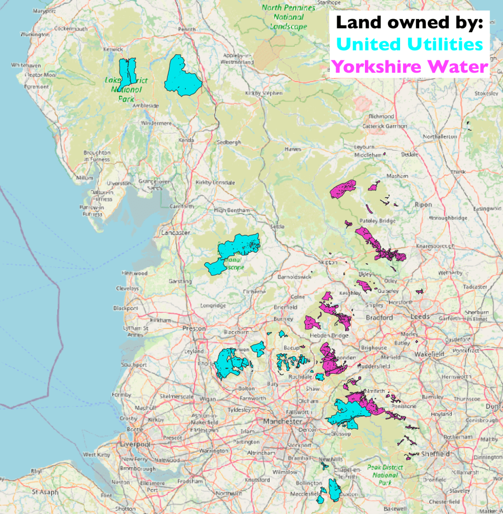
And here’s an interactive Google Map – you can zoom in to see the land in detail:
Mapped area of land owned by:
United Utilities: 140,697 acres
Yorkshire Water: 62,185 acres
How I got the data
In the case of UU, the mapped land corresponds almost exactly to the figure I stated in Who Owns England (2019) (see p.299, Table 4), making it the largest landowning company in England & Wales. I built this map of UU’s land a while ago by analysing company land ownership data displayed via a paid account with Orbital Witness (more details here).
In the case of Yorkshire Water, I obtained a map of their landholdings by requesting the data via the Environmental Information Regulations (EIRs) – a form of freedom of information request that was applied to water companies following a court ruling in 2015. Yorkshire Water’s total landholdings I reckon to be a bit larger than the mapped area: some 68,927 acres in full (see my book, p.299, Table 4). The ‘missing’ 6,700 acres are probably water and sewage treatment works. In my EIR request, I sought to overcome previous objections raised by Yorkshire Water that releasing a map of their water treatment works would breach national security (!). So I stipulated that I wasn’t asking for the locations of water and wastewater treatment works, simply for a map of all watersheds they owned – the land where rainwater runs off into reservoirs and streams.
SSSI units owned by United Utilities and Yorkshire Water
Having a digitised map of land owned by these water companies is very useful, because it can then be combined with other geospatial data to investigate environmental performance.
I decided to do so for Sites of Special Scientific Interest (SSSIs) owned by YW and UU – these are meant to be some of our best-protected nature reserves. Natural England publish a regularly-updated map of SSSI Units complete with their current condition status (graded from Favourable – meaning good condition – through Unfavourable Recovering, Unfavourable No Change, and Unfavourable Declining).
Then – with huge thanks to my friend Lewis Winks (geographer and GIS pro) for his help and advice on this – I cleaned up a few geometry errors in the ownership layers, and used the QGIS function ‘Join by location’ to join the SSSI map to the ownership map. I then weeded out SSSI units that only marginally crossed into water company land (in most cases because of minor disparities in how boundaries had been drawn). A small number of SSSI units extend very slightly beyond the ownership boundaries.
Here’s my first draft of a map of SSSI units owned by these two water companies, shown in static form below, and as a layer on the Google Map above:

Measuring the area of these SSSI units gives us the following provisional results. Of the SSSI units apparently owned by YW and UU (a total of 81,208 acres):
- 7% by area are in Favourable condition (5,939 acres)
- 74% are in Unfavourable Recovering condition (60,332 acres)
- 14% are in Unfavourable No Change condition (11,720 acres)
- 4% are in Unfavourable Declining condition (3,217 acres)
This appears to be even worse than the sector-wide situation, where by area, 16% of English SSSIs owned by water companies overall are in favourable condition.
Major landowners have a particular responsibility to look after the nature in their care – but too many are clearly failing to be good stewards.
Labour must make big landowners like water companies publicly accountable, and set a legally binding target for improving SSSI condition incumbent on all owners. Water companies are already represented on the Major Landowners Group (MLG), a grouping of large public, private and third sector bodies convened by DEFRA and Natural England to manage SSSIs in their care. But Natural England should be given greater sign-off powers on land management plans for members of this group, particularly public sector landowners and those with statutory duties like water companies. The remit of the MLG should also be broadened to cover not just SSSIs, but all land owned by these major landowners – thereby helping the government deliver on its looming Environment Act targets and UN pledge to protect 30% of England for nature by 2030. This could be the beginnings of a groundbreaking new Public Nature Estate.

As usual Guy, a fascinating blog. With particular reference to the southern half of Ilkley Moor, I never knew that this land was owned by them but assumed it was owned by shooting estates – they must just lease Bingley Moor, Morton Moor and Rivock from YW. I’m not surprised the SSSIs are in such a poor state considering that they have just been used for shooting with no thought given to the natural environment – I’ve taken photos of a new road created across the moors this year (by I assumed the shooters) which despoils the area and which I have reported to Natural England and Bradford Council planning department. I wonder what YW think of this or did they, in fact, do it themselves? YW are still dragging their feet over ending grouse shooting on their land as highlighted by Luke Steele and Wild Moors. In contrast I’ve walked across UU land at Haweswater and in the Forest of Bowland and they seem to take a much better attitude to landscape restoration, even if not all their SSSIs are in great condition.
LikeLiked by 1 person
Thank you for this work Guy.
I have read your book and it’s only because of your work that ordinary members of the public like me are informed of how land is owned by so few and helps to maintain their grip on power by their manipulation of legislation and taxation. It’s extraordinary how little the country has moved from the feudal exploitation of land and people.
LikeLike
Regarding UU ownership. I actually think that you may be on the low side for UU ownership. There are some gaps on the West Pennines, you’re missing some agricultural land in West Lancs and Cheshire, and there’s other pockets of land around Lancaster as well (source: me – former UU employee).
Regarding the SSSI status. UU has actually done an awful lot to try and improve the condition of the SSSI’s, it just doesn’t get noticed because it’s incremental, it’s not headline grabbing and, more often than not, it’s quite difficult to explain to the general public what these works entail. The West Pennines only became a SSSI in 2016, so to expect drastic change to the landscape in only 8 years is unrealistic.
Aside from the sheer size of the land parcel to manage, there were also third parties that needed to be engaged with and brought on board including local authorities, tenant farmers, neighbouring landowners, other conservation charities. The list goes on. Some of them didn’t want the land designated as a SSSI at all fearing it affect usage, pastimes and development.
As for NE. Communication between NE and UU is almost daily. The rangers and land managers are very much aware of what needs to be done and the NE and all necessary stakeholders are engaged from the outset on landscape scale land management plans. I would go as far as to say that UU are to some extent NE’s whipping boy and an easy target. Despite a number of notable infractions by neighbouring landowners which affected UU owned land, it was UU that suffered the punishments because the NE knew that the remediation work would get done. They didn’t even bother approaching the “smaller” landowners to reprimand them.
I could write a several hundred word essay on this and whilst there is much to malign about UU, some of their practices and the reason they own the land, but the management of the rural land, particularly that associated with water catchment, should not be part of it.
LikeLike