
This post is by Guy Shrubsole. Image: Exterior of 1 Millbank, erstwhile headquarters of the Church Commissioners. Updated 9th Feb 2020 to show map & acreage of Hoo Estate.
Who Owns England can reveal, for the first time, a map of the land owned by the secretive and powerful Church Commissioners, the Church of England’s main property arm.
The Church Commissioners – who own a 105,000-acre land and property portfolio worth some £2billion – are notoriously tight-lipped about their landholdings. No breakdown of their broad acres can be found in their annual reports, nor is there any published map, despite the Church Commissioners announcing they had digitised maps of their landed assets in 2013. The organisation is also exempt from Freedom of Information law, making scrutiny harder. In correspondence passed to me, a property manager for the Church Commissioners states simply: “We do not give out plans of the Commissioners’ land.”
But an exhaustive investigation has found a workaround, enabling a map to be pieced together revealing two-thirds of the Church Commissioners’ vast estate, and inferring where the majority of the remaining one-third lies.
Mapping what the Church Commissioners own
Any landowner that wishes to protect their estate from future rights of way claims can do so by paying the local council a small fee and lodging with them a map of their landholdings. This obscure rule, section 31.6 of the Highways Act 1980, means that hundreds of landowners’ estate maps lie buried on the back pages of council websites. And the Church Commissioners, it turns out, appear to have registered almost all of their estates in this way.
Scouring council webpages for these maps – and then turning them into digital maps using INSPIRE Index Polygons and free desktop mapping software (QGIS) – has been a lengthy task. Knowing that the well-resourced Church Commissioners already have a secret digitised map of all their landholdings made the process still more frustrating. But here, at last, are the results. All the estates I’ve been able to map are shown here in yellow:
Contains INSPIRE Index Polygons. © Crown copyright and database rights 2019 Ordnance Survey 100026316. There are restrictions on republication of INSPIRE polygons; I am publishing them here for purposes of news reporting under fair dealing. I will take them down if requested by OS.
Calculating the acreage of each estate was done by measuring the area of the polygons:
| Estates of the Church Commissioners | ||
| County | Area | Notes |
| Cambridgeshire | 9,337 acres | Huntingdon Estate & Ely Estate |
| Cumbria | 6,894 acres | Carlisle Estate (5,808 acres) & Newbiggin Estate (1,086 acres) |
| Oxfordshire | 6,648 acres | Islip Estate (1,234 acres), Bishopstone Estate (3,104 acres) & Kelmscott Estate (2,310 acres) |
| Devon | 6,458 acres | |
| Medway | 6,049 acres | Hoo Estate |
| Kent | 5,984 acres | Canterbury Estate (4,433 acres) & Ashford Estate (1,551 acres) |
| West Sussex | 5,945 acres | Chichester Estate |
| Lancashire | 5,791 acres | Halsall Estate |
| North Yorkshire | 3,963 acres | York Estate |
| Lincolnshire | 3,555 acres | South Lincoln Estate |
| Derbyshire | 3,127 acres | Foremark Estate |
| Staffordshire | 2,722 acres | Eccleshall Estate |
| Essex | 2,530 acres | Kelvedon Hatch Estate |
| Somerset | 1,946 acres | |
| North Lincolnshire | 1,636 acres | |
| Herefordshire | 1,017 acres | Hereford Estate |
| Central Bedfordshire | 511 acres | |
| Worcestershire | 358 acres | |
| Land mapped | 74,471 acres | |
| Total land owned by Church Commissioners | 105,000 acres | Source. |
| ‘Missing’ land | 30,529 acres | |
The Ashford Estate is registered in the name of Cedarvale, a subsidiary company wholly controlled by the Church Commissioners. As their 2013 annual report states, “At over 1,500 acres and situated to the south of Ashford town centre, the Estate was acquired for its long-term residential development prospects in the late 1980s.” Much of it is a building site, as the Commissioners sell it off for housing.
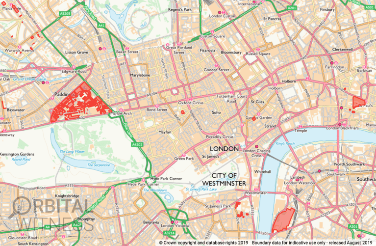
In addition, the Church Commissioners own a number of very valuable properties in London – including the 90-acre Hyde Park Estate near Paddington; Paternoster Square in the City (on a long lease to the London Stock Exchange); the London Lancaster Hotel on Bayswater Road; a row of high-rent shops in Covent Garden; and the Church of England’s political headquarters, the Millbank Estate – including Church House, and Lambeth Palace (residence of the Archbishop of Canterbury). The screengrab map below was generated using the digital mapping tool Orbital Witness.
The data
Here’s a Google Drive folder containing all the Church Commissioners’ Highways Act s31.6 landowner deposit maps I could find on council websites. They’re nearly all PDFs – a few councils have digitised their s31 deposits, so these are just included in the Google Map above as KML files. The folder contains maps of a number of much smaller estates that I’ve not tried to re-build using INSPIRE Polygons, so aren’t included in the table above (the Church’s estates in Warwickshire, Hampshire, Northamptonshire, Bedford, South Tyneside, Nottinghamshire, North Somerset and Norfolk). I’d estimate that these scattered fields and properties don’t amount to more than a couple of thousand acres at most.
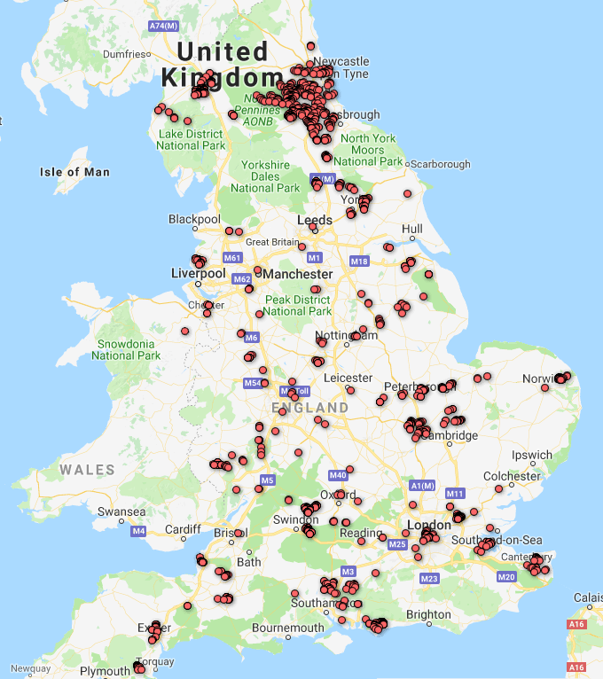
Another source of data on what the Church Commissioners own is the Land Registry’s Corporate and Commercial (‘C&C’) dataset, first released in November 2017. Here’s an extract of the 12,500 land titles it contains registered to the Church Commissioners (including mineral rights, discussed later). Whilst very useful for identifying buildings, the C&C dataset is pretty useless for mapping large tracts of farmland or moorland, as the only geolocation data it provides is where the land title has an associated postcode. Still, a point map of all the postcodes registered to the Church Commissioners is a good way of corroborating what the Highways Act maps show – and highlighting where there’s missing land:
Missing acres
So, having mapped two-thirds of what the Church Commissioners own, where’s the missing one-third?
From the Land Registry point data mapped above, it looks like a lot of it is in County Durham. I checked Durham Council’s Highways Act deposits for the Church Commissioners – they have 3 estate maps deposited for Durham (included in the Google Drive folder linked to earlier). But these appear to only show a fraction of what the Church owns in Durham. If I’m right in my hunch, they own vast swathes of land here – maybe as much as 30,000 acres.
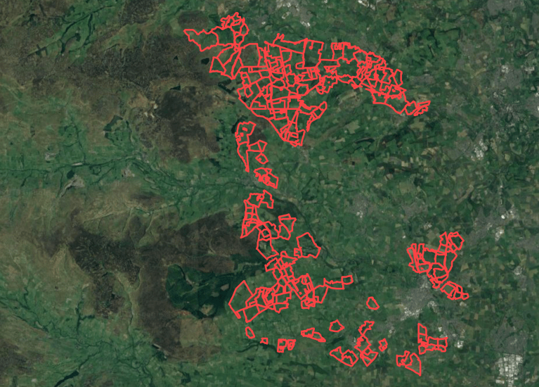
One way I’ve tried to evidence this is through using the online mapping tools Orbital Witness and LandInsight. Both are relatively new startups that have been built off licensing agreements with Land Registry, allowing them to display (behind paywalls) land titles registered in the LR’s Corporate & Commercial dataset, but actually linked to polygon maps of the land parcels in question, not just postcode point locations. Unfortunately, the sheer number of land titles owned by the Church Commissioners in County Durham makes it difficult to view them all on the Orbital Witness interface; and the pay-per-land parcel model that LandInsight has makes it prohibitively expensive to view them all this way, either. Still, this is where I got to with tracking down Church Commissioner land in Co Durham using LandInsight – you can see how they appear to own a huge amount of farmland to the east of the Pennines:
One last way of inferring the land the Commissioners may own in County Durham is by turning to a historical source. This doctoral thesis on 19th century land ownership in the Pennines, by Olivia Wilson at Durham University, contains a map of the area’s landowners in 1850 – reproduced below:
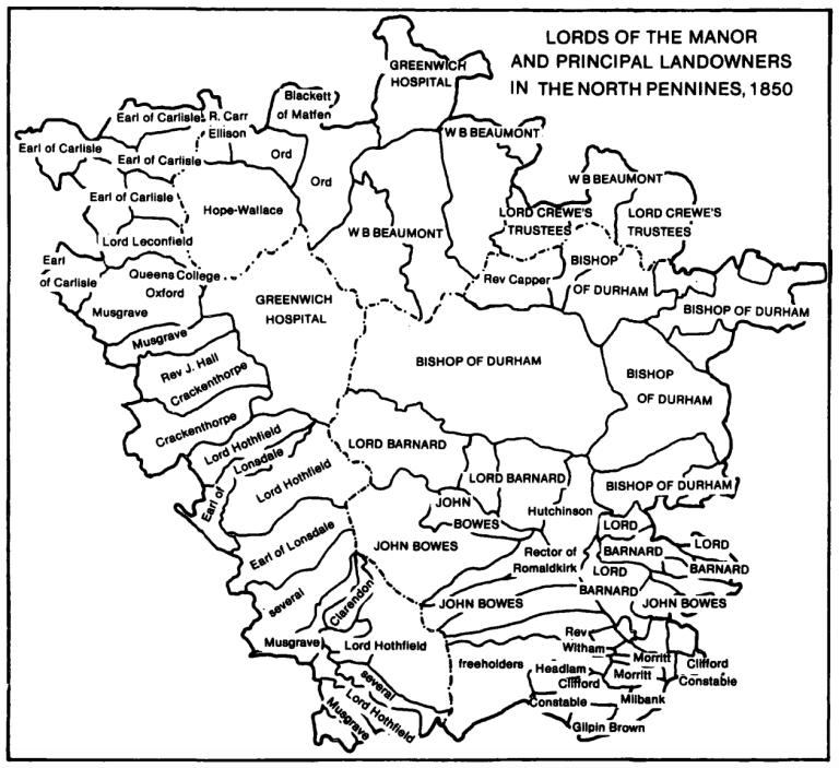
You can see that the Bishop of Durham owned a great swathe of the Pennines in the mid-19th century; could it be that this land has since been passed to the Church Commissioners? I decided to georeference the above map (which means assigning it real-world coordinates, so that it can be matched up to other digital mapping data). It turns out to be remarkably accurate – the current boundaries of the Raby Estate, owned by Lord Barnard, map precisely onto the 1850 map’s boundaries. Overlaying it with the Corporate & Commercial point data for Church Commissioner land shows the Church still owns at least some of what the Bishop of Durham owned 170 years ago:
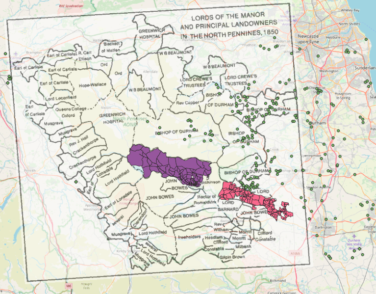
Raby Estates shown in purple and pink; Church Commissioner land titles shown as green points.
A final clue comes from the fact that the 1873 Return of Owners of Land lists the Ecclesiastical Commissioners (the forerunners of the Church Commissioners) as owning 26,868 acres in County Durham.
Mineral rights and forestry land owned outside England
The Church Commissioners also lay claim to around 585,000 acres of mineral rights. Technically, this gives them the right to cash in on stone, metals and minerals beneath the earth, even where they don’t own the freehold to the land above – though obtaining access to dig quarries and mines would require them to compensate the freehold owners. Many of the Church’s mineral rights claims appear to be listed in the C&C data linked to earlier.
The Church Commissioners also have an international forestry portfolio. Their 2018 annual report states: “The Commissioners’ forestry estate covers 103,000 acres in the UK, the US and Australia.” Within the UK, its forestry land appears to be all in Wales and Scotland; the Church’s English estates are all dominated by open farmland. Lo and behold, its 2014 annual report reveals that that year it “bought 17,000 acres of forestry spread across 15 forests in Scotland and Wales. This makes the Commissioners the largest private sector forestry owner in the UK, providing roughly 5% of the UK’s domestic wood supply.”
Responsible investments?
The Church Commissioners’ main reason for owning so much land is because they’re essentially the pension fund of the Anglican clergy. Decisions about what to invest in are driven largely by hard-nosed financial calculation and fiduciary duty.
Yet in recent years, the Church has also rightly come under pressure to invest in socially and environmentally responsible ways. The Commissioners agreed to divest from stocks and shares in coal and tar sands in 2015, and more recently to divest from oil and gas firms too. But do such climate change considerations extend to the way the Church Commissioners manage their extensive land holdings?
Growing trees on the Church’s 105,000 acres, for instance, could lock up a lot of carbon and provide valuable space for wildlife. But the only forests the Church Commissioners seem to own are in Wales and Scotland, not England, and these are commercially-managed conifer plantations managed for forestry, rather than species-rich native woodlands left to grow old. A quick comparison of the Commissioners’ estates with agricultural land grade maps suggests some of the farmland they own is clearly top-quality and best kept for food growing – such as the Grade 1 land they possess in the Cambridgeshire Fens. But even here, there’s a need to urgently consider how to stop the carbon-rich peat soils of the Fens from degrading further, leaking the carbon they store into the atmosphere. And on the Church Commissioners’ more remote, marginal farms – particularly the vast swathes of poor-quality land it owns in County Durham – there is surely space for more trees and woods, even if simply as shelter-belts for livestock.
The Church has declared its responsibility to “safeguard God’s creation”: it should make a start by practising better stewardship of the vast acreages of land it owns.

More excellent work. I surmise these estates are the endowment lands and properties owned by the Church. Could some of the missing acres be churchyards and glebe land? Is this land owned by the Church Commissioners? With some 13000 churches in its ownership and many of them with substantial graveyards surrounding them, the amount of land is going to be significant.
My own slant on this arises from my interest in Grade 1 listed buildings, of which the Church of England has some 5,000.
LikeLike
Hi William, thanks! My understanding is that most churches, churchyards and remaining glebe land is owned by the 42 Dioceses, rather than by the Church Commissioners. The Dioceses own around 75,000 acres, in addition to the Commissioners’ 105,000 acres. But there could well be overlap / exchange in places – the Ecclesiastical Commissioners certainly took on a lot of the land previously owned by the Bishop/ Diocese of Durham, for instance.
LikeLike
I think this is the case. It would be interesting to map these too.
LikeLike
This may be a couple of years after your article, but have only just read it, and you may already know this but the Church Commissioners also own a lot of farmland and a large retail park in Cheshire.
LikeLike
Another fine article. Thank you Guy.
A lot of the Glebe land once owned by the church was sold off by vicars without the knowledge of the Church Commissioners. This lead the CC to introduce the Endowments and Glebe Measure 1976 which came into effect in 1978 – http://www.thelandmagazine.org.uk/articles/adios-landed-clergy
I can recall vicars making a killing and pocketing the cash and retiring down here in Kent.
LikeLike
That is a serious allegation and if true should be investigated. Most glebe land I know of outside the purview of the Dioceses is invested in Parochial Church Councils not Clergy, and they are very protective of it. In my last parish there was some ex glebe land next to the vicarage and it had been sold off to provide social housing- to the irritation of some of the affluent near neighbours.
LikeLike
According to Bill Bryson, one vicar had a glebe of 33,000 acres. As you say, someone made a killing!
LikeLike
That would be Great Doddington, and aiui it was broken up in Victorian times.
Nice try 🙂
LikeLike
I suggest the area owned in Co. Durham won’t have much livestock, unless you include ‘game’ birds as livestock. Much is let out to sheep farmers, so church commissioners will gain the 2/3 EC subsidy at least. And they retain the mineral rights?? Worth a pretty penny. I live near the borders between Durham, Cumbria & Northumberland. Just lent my vicar the Land Reform booklet from 1908(?) mentioned in Who Owns England. He is also vicar for the estate church of the Blackett-Ords, and our local worthy is Blackett-Beaumont. Light blue touch paper and retire.
LikeLike
All glebe land was taken away from the parishes in the 1970s and handed over to diocesan boards of finance, ostensibly to pay clergy stipends, but in practice to employ large numbers of officials in expensive office accommodation. Churches and churchyards belong to the local benefice, not to the diocese. Pension funds belong to present and future pensioners. All this has to be paid for, so it is no surprise that the Church Commissioners manage historic assets in order to do so. Like any business, it keeps detailed information about its investments confidential.
LikeLike
Much of this is correct about Churches and Dioceses owning property. Durham is a large diocese with unusual rights. Indeed the Commissioners own many buidings and smaller properties. Sadly for the clergy in the 1980’s the Church Commissioners sold off badly a number of assests, mostly naturally in towns, this was no small hit, we are talking millions at a time when attendance was also down. I can’t say how I know this but I think your calculations of the estates in Yorkshire is severely down. Go have a shufti.
LikeLike
If this is all true then why is Harbeldown Church near Canterbury pleading for money.Also it was reported in a national paper that a known business man has paid millions for acres of Church Commision land just last month. I did not realise the Church was so secretive and so,so wealthy.
LikeLike
Good evening to ALL. I’m hoping someone can give me some guidance.
I’m trying to locate / find information about the sale of church land in the village of Ferrybridge, West Yorkshire in the 1960’s.
The Conveyance involved 1. The Reverend Clarence Henry Branch 2. The Church Commissioners for England 3. The Dean and Chapter of York and 4. Norman C Ashton Limited
( House Builder ).
LikeLike
The cognitive dissonance of the Church is laughable. They preach awareness of climate change and caring for the land – and at the same time are selling off huge chunks of green fields for developers to build warehouses. Not only does this destroy the natural landscape, it encourages more lorries on the roads, displaces wildlife and invariably leads to more flooding.
https://staunchcampaign.org/
LikeLike
Kevin Cahill’s book, ‘Who Owns Britain’ (2001) gives the Church Commissioners’ acreage by county, though several counties are missing, including Durham, ‘the land of the Prince-Bishops’. He states (page 171) that in the 1996 annual accounts the agricultural holdings are listed in full.
When I was researching land ownership in 1983, the Commissioners sent me a map showing the location of each separate estate, indicated by dots that averaged out at roughly 1,000 acres each. The largest numbers of dots were in Cambridgeshire, Lincolnshire, then Durham. It was good of them to be so open. They’ve really clammed up since.
In respect of Durham, note that the estate is not just in the Durham County Council area. Some particularly valuable farmland on the urban fringe is in the metropolitan districts of Gateshead, South Tyneside and Sunderland. I note that the point data clusters pick up the lands at Boldon and Ryhope that I had some professional dealings with.
LikeLike
So the Church of England are not regulated by the Freedom of Information Act?? I find that incredible. And this land ownership portfolio is for clergy pensions…… I’ve stumbled onto your page ‘cos I wanted a boundary plan of my church and it isn’t available. So doing a bit of googling found your article. Don’t understand much of the terminology, just a simple soul looking for information
LikeLike
I was church warden of a rural parish for 13 years. Apart from working to ensure we paid our share of the common fund, the PCC was responsible for maintaining the fabric of our beautiful Devon Church. With an ageing congregation this became increasingly difficult. Today myself and another former church warden do what we can to continue in the role but without the legal responsibility. It sickens me that the Church of England commissioners continue to control £billions in investments, on the basis that it needs its income to pay clergy pensions etc when the numbers of clergy in the country and the nos in our congregations are diminishing. It really is about time they provided us with help to maintain our churches. We have one priest to look after the souls of 6 parishes, they have an impossible task. It is our churches who have to raise the funds to pay our priest, it does not come from the Church Commissioners. Our Country is in need of Christian Leadership to provide help for the homeless, the poor, the sick, halt and lame. It’s time for the Commissioners to set a Christian example.
LikeLike
Very interesting posts Guy!
Have you seen on the Executive Summary of the Church of England’s “Coming Home” report first paragraph of Part 3 they quote that they hold approximately 200,000 acres of land not 105,000?
They also suggest that they are commissioning a new geospatial mapping
tool by Knight Frank and Eido Research so their land can be repurposed for social affordable housing in some areas. Whether this will be made public though is different question.
https://www.churchofengland.org/about/archbishops-commissions/housing-church-and-community/about-coming-home
LikeLike